Kolmanskop

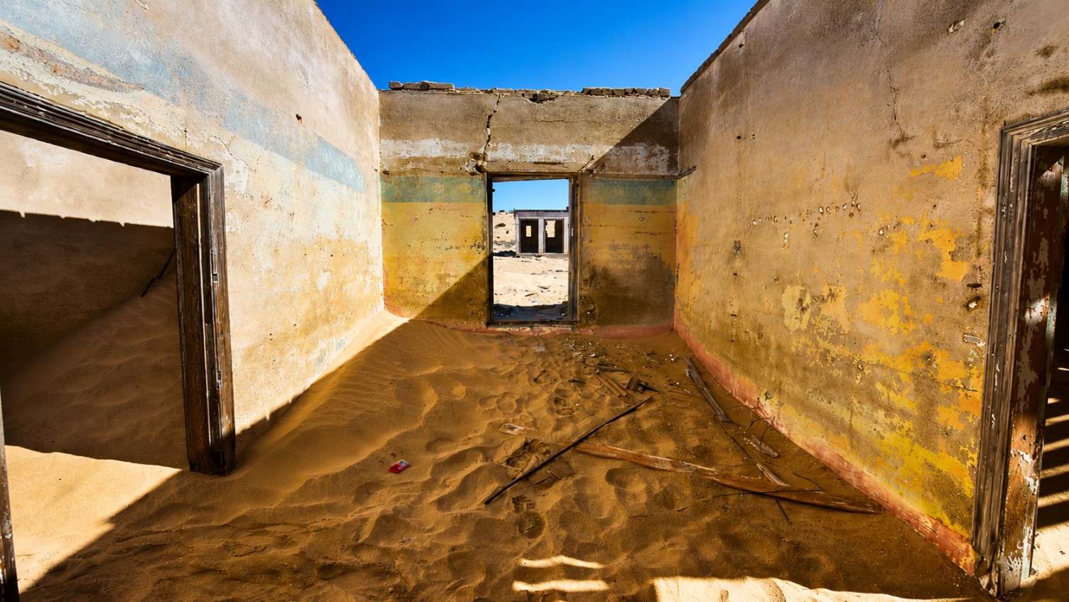
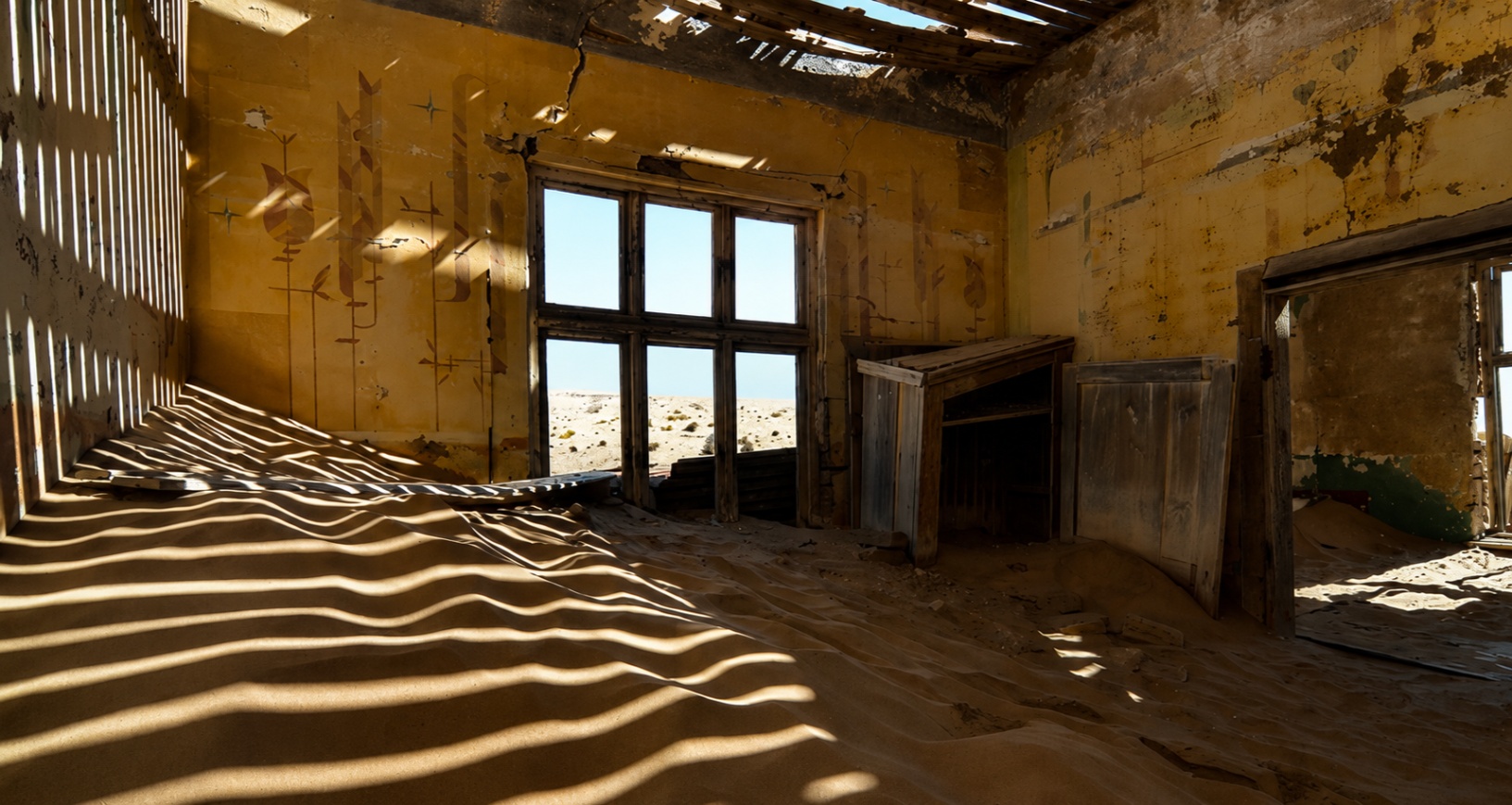
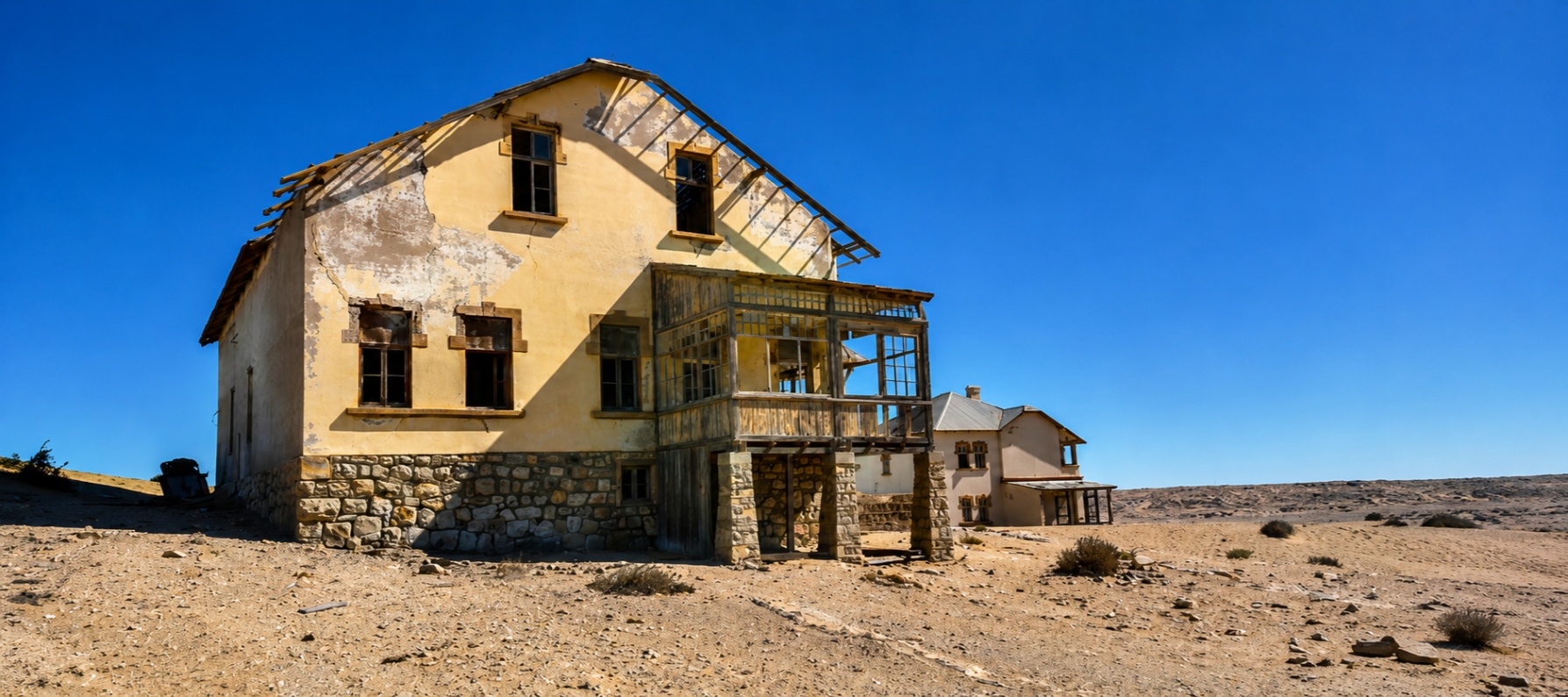
What was once a thriving community complete with a school, hospital, ballroom, theatre, bakery, and ice factory has gradually been reclaimed by the desert. As the sands of the Namib continue to move through the buildings, Kolmanskop stands as one of Namibia's most photographed and intriguing destinations.

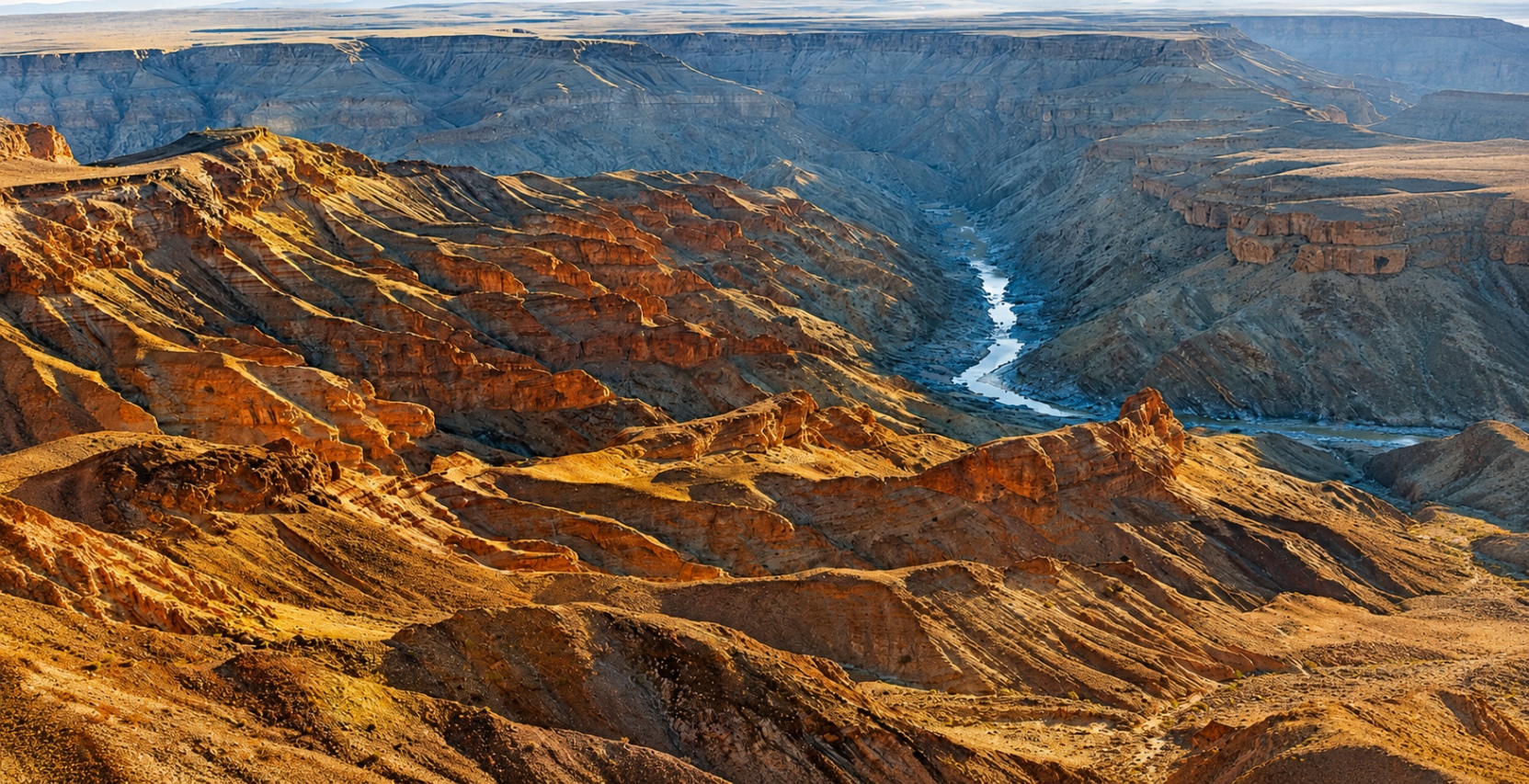
Whether explored on foot or viewed from above, it is a place where history and landscape have become inseparable.

Why Visit Kolmanskop?

Kolmanskop offers something unlike any other destination in Namibia.
Visitors come to walk through abandoned homes where dunes now fill former living rooms, to photograph the striking contrast between German colonial architecture and desert sands, and to discover the fascinating story behind one of Africa’s greatest diamond booms.
Unlike many historical sites, Kolmanskop has not been frozen in time. Instead, it continues to change as wind and sand slowly reshape the buildings year after year.
For photographers, history enthusiasts, and travellers interested in Namibia’s past, Kolmanskop provides a unique opportunity to witness how quickly fortunes can change and how powerfully nature can reclaim what was once considered permanent.

Interesting Facts

Born From a Diamond Discovery

Kolmanskop was established following the discovery of diamonds in the area in 1908, sparking a diamond rush across the region.

Once One of Africa's Wealthiest Towns

At its peak, the town featured a hospital, school, ballroom, theatre, bakery, ice factory, and other facilities rarely found in such a remote desert location.

Ice in the Desert

Fresh water was transported by rail from as far away as Cape Town, while an ice factory supplied residents with ice despite the harsh desert environment.

Named After a Transport Driver

The town is believed to have been named after Johnny Coleman, a transport driver who reportedly abandoned his ox wagon nearby during a sandstorm.

Abandoned in 1956

As richer diamond deposits were discovered further south, residents gradually left Kolmanskop and the town was eventually abandoned.

One of Namibia's Most Photographed Locations

Today, the combination of abandoned buildings and drifting desert sands attracts photographers from around the world.

A Town Slowly Reclaimed By Sand

The desert continues to reshape Kolmanskop, filling abandoned rooms and hallways with drifting dunes year after year.

The Story of Kolmanskop

The story of Kolmanskop began in 1908 when diamonds were discovered near Lüderitz. Almost overnight, prospectors and fortune seekers arrived in the area hoping to benefit from what would become one of the world’s richest diamond fields.
Within a few years, a thriving town emerged in the middle of the desert. Inspired by German architecture and European lifestyles, residents built elegant homes and established facilities that were extraordinary for such a remote location. Kolmanskop quickly became a symbol of prosperity during Namibia’s diamond boom.
The town remained successful for several decades, but by the 1920s richer diamond deposits had been discovered further south near Oranjemund. As mining activity shifted, Kolmanskop’s importance gradually declined. By the 1950s, most residents had left and the town was officially abandoned in 1956.
Today, the desert continues the work that began decades ago. Sand drifts through hallways, fills abandoned rooms, and reshapes the town with every passing year. What remains is one of Namibia’s most remarkable historical attractions and a powerful reminder of the rise and decline of the diamond era.

Fish River Canyon Not Just Another Canyon

Located in the far south of Namibia, Fish River Canyon is the largest canyon in Africa and is widely regarded as the second-largest canyon in the world. Stretching for approximately 160 kilometres through a rugged and remote landscape, it was shaped over millions of years by geological activity and the steady work of the Fish River.

While photographs capture its dramatic scenery, nothing quite compares to standing on the rim and watching the canyon unfold into the distance. Layers of exposed rock, winding riverbeds, and changing colours tell a story that spans hundreds of millions of years.

Whether viewed from a lookout point, explored on foot, or experienced from the air, Fish River Canyon remains one of Namibia's most remarkable natural attractions.

Why Visit Fish River Canyon?

Fish River Canyon offers a side of Namibia that is very different from the dunes of the Namib Desert or the wildlife-rich plains of Etosha.

Visitors come to experience one of Africa’s greatest geological wonders, to stand at viewpoints overlooking the canyon, and to witness a landscape shaped over millions of years by the forces of water, erosion, and geological change.
The canyon reveals something different throughout the day. Early morning light softens the cliffs, midday highlights the textures and colours of the rock formations, and sunset casts long shadows across the canyon floor.
Whether you are a photographer, hiker, nature lover, or simply someone who appreciates wide open spaces, Fish River Canyon offers a perspective that few destinations can match.

Interesting Facts

Largest Canyon in Africa

Fish River Canyon is the largest canyon in Africa and is widely regarded as the second-largest canyon in the world.

More Than 160 Kilometres Long

The canyon stretches for approximately 160 kilometres through southern Namibia.

Up to 550 Metres Deep

In certain sections, the canyon reaches depths of more than 500 metres.

Namibia's Longest River

The Fish River is the longest river entirely within Namibia and remains the natural force responsible for shaping the canyon.

Home to a World-Famous Hiking Trail

The Fish River Canyon Hiking Trail is considered one of Africa's premier multi-day hiking routes and attracts adventurers from around the globe.

Ai-Ais Hot Springs

Located near the southern end of the canyon, Ai-Ais is known for its natural thermal springs and serves as a popular destination for travellers and hikers alike.

A Landscape Millions of Years in the Making

The canyon was formed through a combination of geological faulting, erosion, and the action of the Fish River over millions of years.

Why Visit Fish River Canyon?

The story of Fish River Canyon began long before the canyon itself existed.
Around 300 million years ago, geological activity created a large fault line in the region. As sections of the landscape gradually subsided, a broad valley formed. Over time, the Fish River and natural erosion slowly deepened and widened this valley, creating the canyon visible today.
The exposed rock layers throughout the canyon reveal a remarkable record of southern Africa’s geological history. Each layer tells part of a story that stretches back hundreds of millions of years and provides insight into how the landscape has evolved through time.
Although Fish River Canyon appears ancient and unchanging, the natural forces that shaped it continue today. Seasonal floods, erosion, and weathering still influence the landscape, reminding visitors that nature’s work is never truly complete.

Best Seen From Above

While the viewpoints along the canyon rim offer spectacular perspectives, the true scale of Fish River Canyon only becomes fully apparent from the air.
From above, the winding route of the Fish River can be traced through the canyon below, revealing massive bends, hidden valleys, steep rock faces, and geological formations that are difficult to appreciate from a single viewpoint.
The aerial perspective allows visitors to understand the relationship between the river and the landscape while showcasing the immense size of one of Africa’s most impressive natural landmarks.